
Mills Street stopbank

Mills Street stopbank
From late February to early October, we’re upgrading the existing stopbank between Melling Link Bridge and just north of Mills Street.
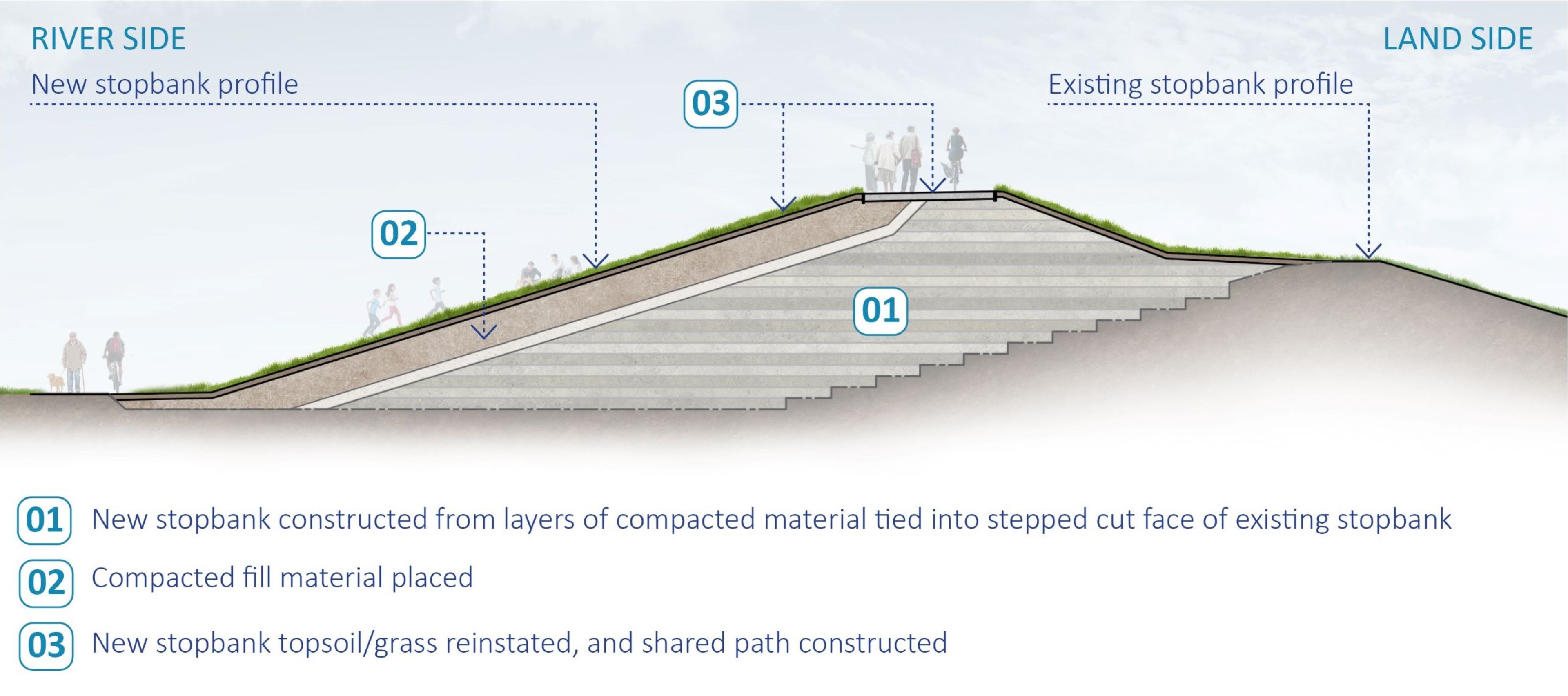
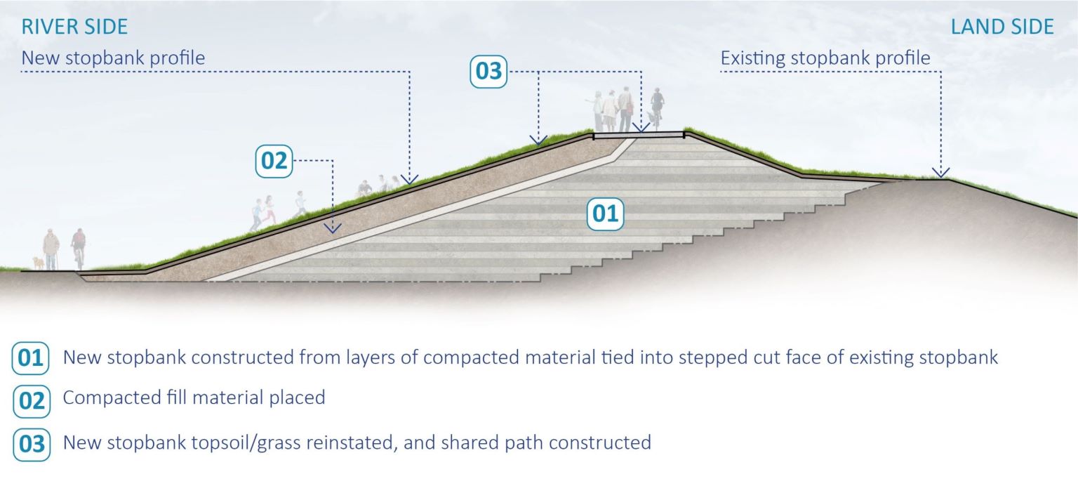
The construction of the Mills Street stopbank is an important milestone. The existing stopbank between Melling Link Bridge and just north of Mills Street currently has the lowest level of flood protection in the area. The existing stopbank provides protection from a 1 in 65-year flood event. In any year there’s a 1.5% chance of a flood that size happening.
The upgraded stopbank will be mostly in the same location as the existing stopbank but will be approximately 1.5 metres higher, allowing more water to pass safely during floods. When all the works under Te Awa Kairangi programme are completed, the Hutt Valley will be protected from a 1 in 440-year flood event including for future climate change (with a 0.2% chance of a flood that size in any year).
Construction of the stopbank between Melling Link Bridge and just north of Mills St has been prioritised. This is due to the critical need for improved flood protection, and to reduce the vulnerability of nearby residences, and other assets to potential flood-related damage.
There are existing high voltage cables (33kV and 11kV power cables) on the landside of the existing stopbank in two locations. They are near Mills Street, and where the upgraded stopbank connects to the existing Melling Link Bridge abutment, and are imperative to the Hutt city power network. Due to the type of cables, these cannot be relocated in small sections, only in longer sections between substations. We are required to maintain continuous operation of these high voltage cables, so the construction of the stopbank has been separated into two stages.
Stage 1 (late February – early October 2024)
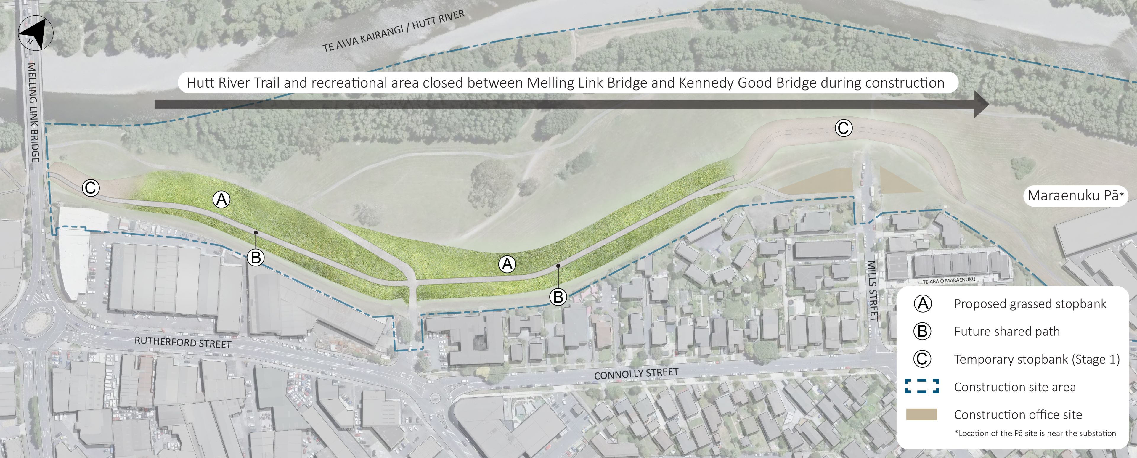
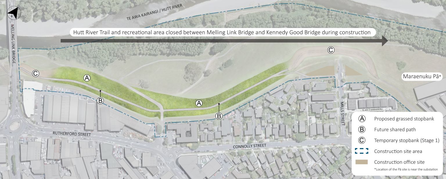
Stage 1 involves the construction of the permanent stopbank and two temporary stopbanks as shown on the image below. The temporary stopbank near the existing Melling Link Bridge will remain in place until the existing bridge is demolished, and then the permanent stopbank will be constructed towards the south.
The temporary stopbank near Mills Street will serve as a temporary flood protection measure until the high voltage cables can be relocated. The timing of the cable relocation has not yet been confirmed, and a temporary stopbank is being constructed in this location in the interim.
Stage 1 will also include introducing riprap (large rock), excavation and processing of river gravels along Harcourt Werry Drive. While the bulk of the work will be off the road edge, there will be temporary traffic management set up along Harcourt Werry Drive to enable these works to occur safely.
Stage 2
Stage 2 of the Mills Street stopbank construction includes the movement and installation of new cables, and subsequent transfer of power, before the existing cables can be removed, and construction of the stopbank in its final location. These works must be phased with wider project works (start dates to be confirmed) for the reasons outlined above.
Riverbank area temporarily closed
During the construction of the Mills St stopbank (Stage 1), the Hutt River Trail and recreational area on the eastern side of the river is closed between Melling Link Bridge and Kennedy Good Bridge. The western shared path is still open in its entirety.
Progress Update: The construction site was set up in late February. It includes a site office at the end of Mills Street, gravel extraction and associated processing sites. From 25 March, construction activity will increase on site. The team will begin gravel extraction works, building the gravel processing facility and tracks for the dump trucks to use inside the site area, to deliver the material for the permanent stopbank. The dump trucks will be contained within the site area, and will not impact road users.
Site closure area: Riverbank reserve between Melling Link Bridge and Kennedy Good Bridge, including the Hutt River Trail and recreational area.
Stopbank construction area: Melling Link Bridge to just north of Mills Street.
Duration: Late February–early October 2024
Alternate routes: Please follow diversion signs. Shared path on the western side of
the river (connecting to Block Road) is still open. Pedestrians can also use the footpath on Connolly St.
We know this work will cause some inconvenience. To ensure your safety, fencing and wayfinding signage will be installed to direct users of alternate routes. Traffic management will also be in place on local roads near the construction area; however, access to residences and businesses will remain open. We’ll follow the Environment Court consent conditions, including the project noise standards, and try to minimise impacts as best as possible. No work will occur on Friday or Saturday nights, or during public holidays.
Regular updates relating to construction progress and traffic management will be shared on this page and via our Facebook page.
We will endeavour to reopen this area as soon as possible. Thank you for your patience while we undertake this important work.

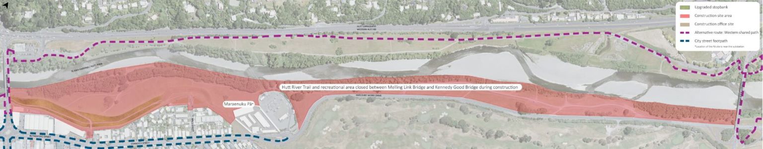
Maraenuku Pā site of significance
North of the Melling Bridge and within the construction area of the Mills Street stopbank is Maraenuku Pā. The pā (settlement) is an area of cultural significance to Mana Whenua and was located in the vicinity of the electricity substation on Connolly Street.
It was established in the period 1839 to 1846, prior to colonisation, by Ngāti Tama from Taranaki and Ngāti Rangatahi from Ōhura (upper Whanganui River) who were closely allied to Ngāti Toa leader Te Rangihaeata.
Maraenuku Pā was built, and gardens were established even as shiploads of European settlers started to arrive in the Hutt Valley to take up blocks of land they had purchased in London from the New Zealand Company.
The sections purchased by John Boulcott were occupied by his son, who started trying to farm the land. This was close to, and part of the land occupied by Ngāti Rangatahi and in proximity to Maraenuku Pā.
The pressure on areas settled by Māori pā increased and through 1844, Ngāti Tama and Ngāti Rangatahi went on the offensive to protect the land they claimed.
The disputes for the land culminated in what became known as the Battle of Boulcott Farm and those associated with the pā were forced out. Maraenuku pā was demolished by British troops on 27 February 1846.
While no trace of the pā remains today, the history of Maraenuku Pā and the mana associated with that area does. This provides us with the opportunity to acknowledge that site and share its history with the people of Te Awa Kairangi.
We acknowledge Morris Love (Te Āti Awa, Taranaki, Ngāti Ruanui and Ngāti Tama iwi of Taranaki) for providing the cultural history about the project area.
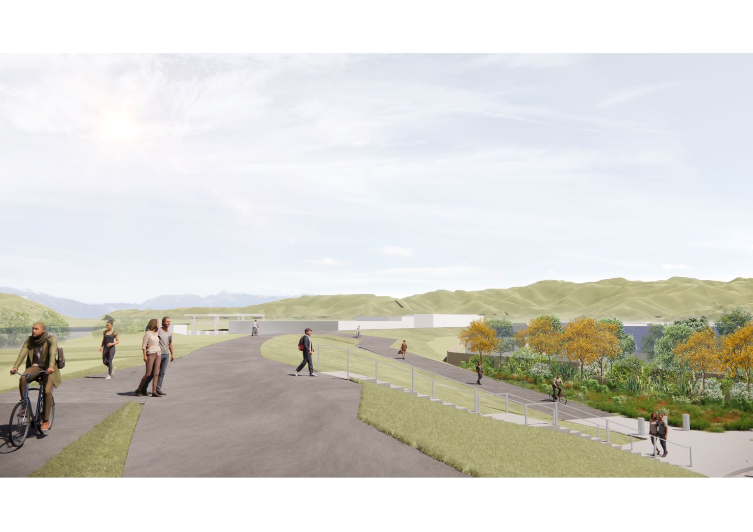
An artist’s impression of the future stopbank is shown below.

Project Liaison Person
For queries relating to these works, please reach out to:
Robbie Woods - Kaiwhakahaere Matua (Project Manager), Te Wai Takamori o Te Awa Kairangi - Delivering RiverLink
M 021 256 6056
or email us at info@teawakairangi.co.nz